![]() 1st Battalion 22nd Infantry
1st Battalion 22nd Infantry ![]()
Night Ambush Patrols Tuy Hoa 1971
In late October 1970 1st
Battalion 22nd Infantry was detached from the 4th Infantry
Division and came under direct control
of 1st Field Force Vietnam (IFFV). From November 1970 until
January 1971 our Company was shuttled back and forth
between the coast at Tuy Hòa and Phú Hiêp and the Base Camp at
Camp Radcliff, in the interior of the country at An Khê.
Also during this time the 4th Infantry Division went home and we
guarded the Base Camp at An Khê while watching the Division
go home without us.
Beginning in early January 1971,
once the Battalion was permanently stationed at the Base at Tuy
Hòa our Company alternated
between guard duty in the bunkers and towers inside the Base and
running night ambush patrols in the countryside around the Base.
We continued these duties until the end of March or beginning of
April when our Company was tasked with a mission back in the
interior of the country. The Base at Tuy Hòa was on the beach
and went right down to the water’s edge of the South China
Sea,
so the entire eastern side of the Base’s perimeter was the
ocean itself.
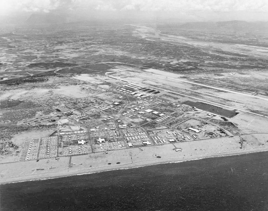
The Base at Tuy Hòa – North is to the right
The South China Sea is
at the bottom. The airfield is on the right. We lived in the
barracks in the far lower left of the photo.
In the upper right is the Ðà Rang River. In the hazy distance
the mountains can be seen. In the upper left are the beginnings
of the rice paddies.
When this photo was taken the paddies were flooded. From January
through March 1971 the paddies were mostly dry.
Photo of Tuy Hòa Airbase taken in 1969 by Pete Kessler from the Photomapping in SE Asia website
Tuy Hòa Air Base had been built
in 1966-67 to house a Wing of F-100 fighter-bombers for the U.S.
Air Force. In late 1970
the Wing was redeployed to the continental U.S. and the U.S. Army
took over the Base. In January 1971 our entire Infantry
Battalion was permanently stationed at the Base which was now
renamed as the U.S. Army Airfield, Tuy Hòa. Compared to most
Army Bases in Vietnam this one was luxurious living for Infantry
soldiers. Since it had been built for the Air Force the barracks
had better construction, the roads were asphalt instead of dirt
and there were better amenities such as an actual movie theater.
There were even concrete sidewalks connecting the buildings. The
barracks had standard stateside Army bunk beds instead of the
folding cots we were accustomed to at our Base Camps and there
was running water in the latrines. Army Infantry Base Camps
in Vietnam did not have running water but apparently the Air
Force couldn't live without it.
It was a touch of civilization we weren’t used to.
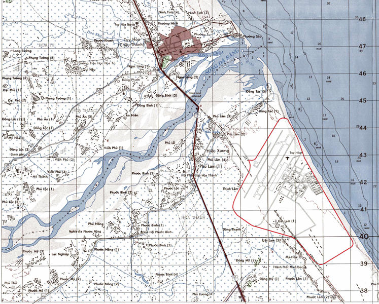
Above: Map of Tuy Hòa area – North is to the top.
Brown blob at top of
above map is the city of Tuy Hòa. Long blue-gray shading below
that running from left to right is the Ðà Rang River
(Sông Ðà Rang) flowing into the large blue-gray blob at right
which is the South China Sea. This was the eastern coast of the
country of South Vietnam.
The country was officially called the Republic of Vietnam (Viêt
Nam Công hòa.) Dark line running through the center of the map
is Highway 1 (QL 1).
The U.S. Army Base is in the right center outlined in red. Areas
with marsh symbols indicate rice paddies with named villages.
Map of Tuy Hòa area is from the
1: 50,000 grid map Sheet 6835 II. This is the same kind of map we
used in Vietnam
as our operational maps for patrols and missions. Base outlined
in red on map by Michael Belis.
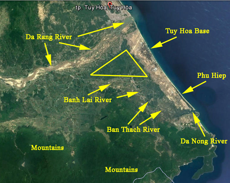
Google satellite image of Tuy Hòa area. North is to the top.
Though the above image
was taken in 2017 the basic geography of the area remains much
the same as it was in 1971. The city of Tuy Hòa
is marked at the top of the image. The dark blue on the right is
the South China Sea. The area of the night ambush patrols was
roughly in the
yellow triangle marked on the image with the Tuy Hòa Base to the
east, the Ðà Rang River to the northwest and the Bánh Lái
River to the south.
The southern mountain range begins immediately to the south of
the Bánh Lái River. To the west the western mountain range
begins (in the left,
out of the above image.)
The area in the triangle
was the delta formed by the two rivers and consisted of flat rice
paddy land dotted by small villages that mostly lay
along the highway which paralleled the coast.
Phú Hiêp was a few
miles to the south of the Base at Tuy Hòa and was several
fishing communities clustered together near the mouth of
the Ðà Nông River (Sông Ðà Nông) where it emptied into the
South China Sea. After crossing Highway 1 the Bánh Lái River
became the
Bàn Thach River (Sông Bàn Thach) and then merged into the Ðà
Nông River. There was a small airfield at Phú Hiêp which
housed a squadron
of Grumman OV-1 Mohawk surveillance aircraft.
Google satellite image from the Google Earth application with yellow markings applied by Michael Belis
The Base at Tuy Hòa was right
on the flat sandy area of the beach. To the west of the Base was
a chain of mountains ranging to
about 1400 feet high and about seven miles away. In between those
mountains and our Base were miles of rice paddies with small
villages or clusters of houses sprinkled here and there. The
local communist Viet Cong (Viêt Công) organizations carried out
operations
both from those mountains and some of the villages.
An entire Infantry Battalion
being stationed at the Base at Tuy Hòa gave it more protection
than it ever had. One advantage was
the availability of a large number of trained Infantry who could
be deployed in an extra ring of security around the Base through
the use of night ambush patrols. By being set up in the
countryside around the Base the patrols could prevent enemy
attacks against
the Base or at least provide advance warning giving the Base time
to bolster its defenses. During the few times when one of our
patrols
engaged enemy forces in a fight the result was the loss of
surprise by the enemy causing him to cancel his attack on the
Base.
Detection by one our patrols could also disrupt other enemy
activity and movements in the area.
We had five Companies in our
Battalion, Companies A (Alpha), B (Bravo), C (Charlie), D (Delta)
and E (Echo) to provide men
for guard duty at the Base and night ambush patrols. Apparently
those duties were rotated among the Companies as we would
alternate between pulling guard and conducting patrols with the
occasional day/night off. As a non-commissioned officer I was
also
sometimes detailed as Sergeant of the Guard or otherwise got a
little more time off than the other enlisted men. Our medics were
exempted from going out on these patrols.
Standard operating procedure for
the patrols was to go out into the rice paddies and set up an
ambush to cover a likely avenue
of approach that the enemy might use when coming down from the
mountains to attack the Base or to otherwise move through the
area.
That avenue could be one of several dirt roads which ran through
the paddies connecting village to village or it could be any of
the paddy
dikes which crisscrossed the countryside. There was a curfew in
the area after dark so it was assumed that anyone moving through
the
countryside at night was the enemy.
I cannot remember if the size
and location of each ambush was designated by Battalion
Headquarters or if Headquarters assigned
each Company a general area of responsibility and left the size
and location of each ambush up to the Company. My Platoon
Sergeant
dragged me along to one of the briefings at Battalion
Headquarters and the only thing I remember from that briefing
were the overall numbers.
At that briefing there were several boards aligned with each
other and across those boards were spread a number of adjoining
maps of the area
around the Base arranged to form one huge map which encompassed
the area all the way into the mountains. On the maps were marked
the
estimated locations or areas of operations of known enemy units
that had been identified by either intelligence or reconnaissance
reports.
Knowing the size of each enemy unit by its designation of either
Company, Battalion or Regiment, I was able to make a quick
estimate
that there were about 1300-1500 enemy soldiers in the immediate
area to face our Battalion which numbered about 800-1000 men,
usually minus one of our Companies on detached duty at any given
time. Of course there were South Vietnamese units in the area
as well as South Korean units and both were our Allies so we
weren’t as outnumbered as it seems. The area around Tuy Hòa
was never
fully pacified during the entire war. A number of villages in the
area were considered to be sympathetic to the enemy.
The enemy was always around and from time to time made his
presence known.
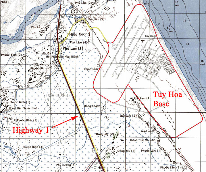
Above: Enlargement of map showing the Base and Highway 1 - North
is to the top.
The Base is outlined in red.
To deploy for night
ambush patrol we would leave the Base in trucks exiting through
the main gate (on the above map near the top of the Base
where the red lines merge to an inverted “v”) and take
that road heading north through the village of Phú Lâm (2),
turn west (left on the map)
and move to Highway 1 and then down the highway heading south
(yellow line). At intervals the patrols would be dropped off
along the highway
to make their way into the rice paddies on either side of the
road. Each patrol had its own designated map co-ordinates as to
the approximate
location of each ambush, and each location was anywhere from a
few hundred yards to a few miles into the countryside. Every
patrol had a unique
radio call sign which was linked to its assigned location.
The end of the patrol
was at first light. Just before dawn the patrols would dismantle
the ambushes and move back to the highway to await pickup
usually by the same truck and driver who dropped them off the
night before.
Map of Tuy Hòa area from the 1:
50,000 grid map Sheet 6835 II
Red and yellow markings added by Michael Belis
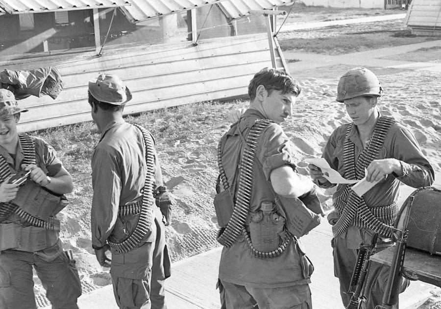
Members of 3rd Platoon Company C at the Base at Tuy Hòa getting
ready to go out on night ambush patrol. On the right is Henry
"Ski" Jankowski,
machine gunner. The flash hider and folded bipod of Ski’s
M-60 machine gun can be seen in front of him leaning against the
table. Second from the right
is John “Goose” Bryce, assistant gunner. Ammunition
belts for the M-60 machine gun being carried by everyone.
Note canteens and bandoleers of rifle magazines.
Photo by Michael Belis
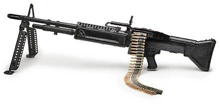
M-60 machine gun
Photo by U.S. Ordnance Inc., via Warboats website
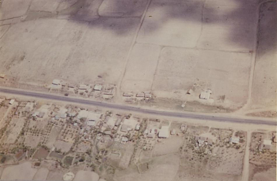
View of section of Highway 1 in the area around Tuy Hòa. Most of
the houses in the bottom part of the photo can be seen to have
fruit tree orchards
behind them. Note dry rice paddies in upper part of the photo
with paddy dikes and a couple of small roads or large pathways
going through the paddies.
From January to April 1971 the paddies were mostly dry.
Photo taken aboard a Huey helicopter in a flight from Tuy Hòa to Phú Hiêp either late 1970 or early 1971 by Michael Belis
On some occasions one or more
patrols worked together with a unit of the local South Vietnamese
Regional Force/Popular Force militia
and set up ambushes to prevent entry into a village. The
abbreviation of those militia units’ designation (RF/PF)
gave rise to the slang name
we knew them by. We called them “Ruff-Puffs”. At the
time I never knew the exact designation of the local militia
units that we worked with.
I’ve since learned that the 206th and 217th Regional Force
Battalions of the Republic of Vietnam Territorial Forces were
stationed in Phú Yên
Province so it was one or both of those units we most likely
partnered with.
The size of each patrol varied
and after the first week or so that we began conducting them the
size settled into being between
a minimum of five men and a maximum of ten or twelve.
Each patrol normally had one
M-60 machine gun, usually one of the men in the patrol was a
grenadier who carried an M-79 grenade launcher
and the rest carried M-16 rifles. Each patrol also carried at
least one M-18 Claymore anti-personnel mine and at least one trip
flare. Extra
Claymores and trip flares could be utilized depending upon the
individual patrol’s size and specific mission. Every patrol
carried a portable
AN/PRC-25 “backpack” radio to keep in contact with
Headquarters back at the Base.
Individual loads depended upon
each soldier’s personal decision. Ammunition was the first
priority. When we first started running these
night ambush patrols many of us carried our rucksacks. After
months of operations in the jungle we were accustomed to carrying
everything
we needed either inside of or attached to our rucksacks and stuck
in our pockets. As time went on most of us dispensed with the
rucksacks
on these patrols and found other ways of carrying what we needed.
Most of us carried magazines for
our rifles in bandoleers, each of which could hold seven
magazines while the standard Army issue load
of two ammo pouches on a pistol belt held a total of eight
magazines. Two bandoleers therefore could hold about as much as
four ammo
pouches and were much easier to carry. Since the ambush posture
demanded we lay on our stomachs the box type ammo pouches would
also be incredibly uncomfortable to lie on for any length of
time. Bandoleers could be slung over a shoulder or tied around
the waist and
some of us wore a bandoleer jury rigged across our chest. Some
carried magazines for their rifles in Claymore bags which could
be hung
from the shoulder though the bags were usually used to carry the
Claymore anti-personnel mine they were designed for. Ammunition
for
the machine gun was carried in loose belts draped around waists
or across shoulders, that burden being shared among the members
of
the patrol. Hand grenades were not issued.
When available a night vision
device was carried. We only had a few of them but those first
generation models were low resolution
and only worked efficiently about half the time anyway.
A rubberized Army issue poncho
was carried by most men. If the ground was wet a soldier could
spread out the poncho to lie on.
The nights could be surprisingly cool down on the coast so the
poncho could be used to cover up with. For the same reason
some carried both a poncho and quilted nylon poncho liner. A
soldier could lay on the poncho and use the liner as a blanket.
A few men wore an M65 field jacket to ward off the breezes
blowing from the ocean. It may be difficult to believe that a
soldier
would wear a field jacket in Vietnam. When the temperature
dropped from 110-120 degrees in the daytime to the lower
70’s or
even upper 60’s at night, that was a 40 to 60 degree drop in
temperature that a body had difficulty in dealing with and with
that cool
breeze blowing off the ocean it could actually get chilly laying
in those open rice paddies all night long. And of course on those
nights when it drizzled or rained that poncho or jacket could
help to keep a soldier from being completely miserable.
A canteen of water was a
necessity. For that reason alone many guys wore a canvas pistol
belt at their waist. The canteen in its pouch
was made to be attached to the belt and the rolled up poncho
could be tucked over the belt or tied to the belt with bootlaces,
usually at the back of the belt. Hand launched parachute flares
were carried to light up the battlefield should a patrol get in a
fight.
They were normally just stuck in the large cargo pocket on the
thigh of our fatigue trousers.

Above: Hand launched M 127A1 parachute flare
Photo from Moore Militaria website
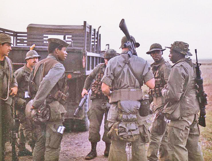
Above: Left to right: Mark Marshall, Rodrigue, Webb, unidentified
- Stapleton?, Don Mitchem, Sylvester Bobo, Gene McGray
The above photo shows guys from my platoon
(3rd Platoon Charlie Company) stopped with the 2 ½ ton truck
which brought them along Highway 1
on deployment of night ambush patrols. These men do not make up a
single patrol as there are three grenadiers in the photo and
there was normally
only one grenadier per patrol. We could usually pack 3 or 4
patrols into a single truck and since everyone is out of the
truck there are more men
that are not in the frame of this photo. The grenadiers, which
are Webb, the unidentified (whose name I think might be
Stapleton) and
Sylvester Bobo are wearing the ammunition vests for the 40mm
grenade rounds. Bobo is wearing a bandoleer of magazines at his
waist because
he is carrying both an M-79 grenade launcher and an M-16 rifle.
The guy who I think is Stapleton is holding his M-79 grenade
launcher
with his right hand. The M-79 was an excellent weapon which
operated like a break-open single shot shotgun and fired a 40
millimeter
high explosive round out to an effective range of 400 meters. It
also could fire a
“shotgun round” which contained double ought buckshot
for close range.
McGray’s rifle has a night vision
"Starlight" scope mounted on it. McGray and Bobo are
wearing M-65 field jackets. Note the rolled up ponchos
and camo poncho liners suspended from the waist. Webb and McGray
have Claymore bags slung at their sides and Webb has parachute
flares
stuck in the leg pocket of his trousers. Bobo also has parachute
flares in his trouser pocket.
Photo by Michael Belis
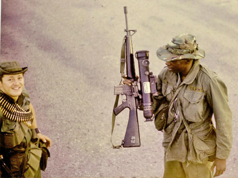
Left: Bill Crane – right: Gene McGray
Crane has bandoleers of magazines for his
rifle, ammo belts for an M-60 machine gun and a Claymore bag
which hangs at his left hip
holding an M-18 Claymore mine. Crane would later be critically
injured in a helicopter crash in April 1971 near LZ Action and
evacuated
back to the States. McGray’s rifle has a first generation
night vision AN/PVS2-A "Starlight" scope mounted on it.
McGray has two
Claymore bags, one slung on either side holding his rifle
magazines and whatever else he deemed needed on the patrol.
McGray is also
wearing an M-65 field jacket to ward off the chill of the night
air. Photo taken along the asphalt of Highway 1 during deployment
of
night ambush patrol in early 1971.
Photo by Michael Belis
|
Left: AN/PRC-25 radio Photo from the 1st Battalion 12th Infantry Regiment website |
Right: Standing along Highway 1 Photo by Michael Belis |
|
|
Left: Photo of me as we were getting
ready to go out 21 magazines in the bandoleers
plus the loaded magazine I loaded 18 rounds in each
magazine instead of the usual 20 My rucksack is strapped to my
back. In it I had a poncho, The Army issue boonie hat
I’m wearing in the photo and one Photo by Michael Belis |
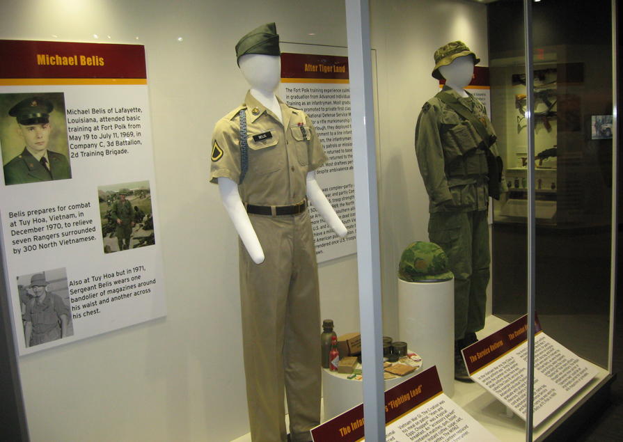
A permanent display at the
U.S. Army Museum on the Base at Fort Polk, Louisiana.
Both mannequins represent me and contain artifacts I wore in the Army.
The khaki uniform on the
left is what I looked like upon graduation from Infantry training
at Fort Polk in either late August or early
September 1969. The name plate, chest ribbon, marksmanship badge
and collar insignia are actual items I wore on my uniform in
Germany
1969-1970 before being sent to Vietnam in August 1970.
The green jungle
fatigues on the right are an actual set I wore in Vietnam
1970-1971. This mannequin represents me on night ambush patrol
around Tuy Hòa in 1971 although I would have never worn that
chest bandoleer so loose and I never carried a Claymore bag. The
boonie hat
and boots are also items I wore in Vietnam and brought home along
with the fatigues. Photos of me are on the poster board on the
left.
Photo by Michael Belis
Home | Photos | Battles & History | Current |
Rosters & Reports | Medal of Honor | Killed
in Action |
Personnel Locator | Commanders | Station
List | Campaigns |
Honors | Insignia & Memorabilia | 4-42
Artillery | Taps |
What's New | Editorial | Links |